


















The OECD.AI Policy Navigator

Our policy navigator is a living repository from more than 80 jurisdictions and organisations. Use the filters to browse initiatives and find what you are looking for.

Alicia — AI-Assisted Severe Weather Detection and Nowcasting for the Caribbean


-
Added by:   OECD analyst
Added on:   27 Oct 2026
Updated by:   OECD analyst
Updated on:   27 Oct 2026

undefined
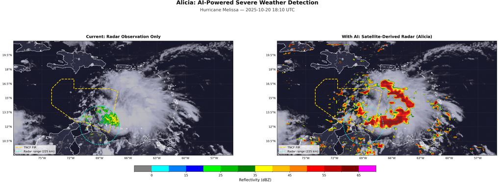
The Meteorological Department Curaçao is developing Alicia, an AI agent that translates satellite imagery into radar-like severe weather maps across the Caribbean. Forecasters currently examine more than 300 images per analysis cycle to issue aviation and public safety warnings. Alicia uses deep learning to extend radar coverage beyond the physical radar’s 225 km range, enabling earlier detection of thunderstorms and improving aviation safety warnings across the Curaçao Flight Information Region

Name in original language

Alicia — Detekshon i Pronóstiko di Tempo Severo ku Intelihensia Artifisial pa Karibe

Initiative overview

The Meteorological Department Curaçao (MDC) is the designated authority for aviation weather services within the Curaçao Flight Information Region (TNCF), covering approximately 200,000 km² of Caribbean airspace. MDC issues SIGMETs, aerodrome warnings and public severe weather alerts.

Forecasters examine satellite imagery across multiple spectral channels, radar reflectivity at several scan levels, lightning observations and numerical weather prediction output, easily exceeding 300 images per analysis cycle. This makes systematic analysis of all data impractical for a single forecaster, and the process relies on subjective selection of which data to examine.

Alicia addresses this by training a deep learning model to synthesise satellite observations into radar-equivalent reflectivity maps, extending the physical radar’s 225 km coverage across the entire FIR. The super-resolution U-Net takes 2 km satellite data from GOES-19 infrared, water vapour and lightning channels and produces 0.7 km radar reflectivity predictions, a 3.2× resolution enhancement. Training uses 24,535 co-located satellite-radar observation pairs collected over 211 days.

The project has four phases. 

  • Phase 1, completed as a proof of concept, demonstrates pseudo-radar generation from satellite data. 
  • Phase 2 adds thunderstorm area identification using lightning as labels, validated against ground observations. 
  • Phase 3 introduces nowcasting to predict storm evolution 0–6 hours ahead. 
  • Phase 4 integrates the model into forecaster workflows to generate draft SIGMETs and warning products in ICAO-compliant formats.

A Memorandum of Understanding with Blue NAP Americas provides GPU training infrastructure comprising four NVIDIA L40S units. Phase 2 continues this partnership with expanded datasets and revised training strategies. Curaçao’s C-band dual-polarisation radar has a historical archive extending back to 2015, with potential to support hydrometeor classification and hail detection.

Central to the project is a meteorological training data lake: a versioned repository bringing government satellite, radar, lightning and numerical weather prediction data into a unified format optimised for AI training. Hosted on Blue NAP infrastructure, it enables Alicia to be trained in specialised modes as new data sources are incorporated. 

The initiative benefits aviation (improved SIGMETs, reduced weather-related delays), marine operations (search and rescue), public safety (earlier severe weather warnings), and regional meteorological research. 

Other relevant details

Results, outcomes and impacts: Phase 1 POC achieved a Critical Success Index (CSI) of 0.123 for storm detection. The VIL hazard-index label approach improved severe storm detection 3.5× compared with the baseline (CSI@45 dBZ = 0.035). Channel ablation studies showed that satellite brightness temperature differences contributed a 13% increase in CSI, the single largest improvement. The model detects 37% of storms (POD), with a false alarm ratio of 0.74, which the submission describes as comparable to early-stage operational nowcasting systems. An inference prototype generates FIR-wide prediction maps in real time. Quantitative evaluation uses CSI, POD, FAR, RMSE and SSIM metrics against held-out radar observations. Challenges and lessons learned: The first challenge was sparse target data: radar echoes cover only approximately 5% of pixels, causing the model to collapse to all-zero predictions. A compound loss function combining binary cross-entropy with Tversky loss was essential to overcome this. The second was data alignment: satellite and radar use different projections and resolutions, making careful reprojection critical. The submission reports that scipy.griddata produced artefacts, while rioxarray.reproject resolved the issue. The third was infrastructure: training on remote GPU infrastructure across 12,000 km introduced latency, making reliable data transfer and deployment automation essential. The fourth was label quality: radar labels include non-meteorological echoes, such as clutter and sea spray. Dual-polarisation filtering is planned to reduce false alarms. Conditions for success include embedding domain expertise in the development process, with forecasters defining severity thresholds; access to co-located, multi-source observations; and iterative experimentation with systematic tracking of model variants.

About the policy initiative


Category:

  • AI policy initiatives, programmes and projects

Initiative type:

  • AI use cases/projects in the public sector

Status:

  • Active

Start Year:

  • 2025

OECD AI Principles:

—

Other relevant urls:

—

Images: