


These tools and metrics are designed to help AI actors develop and use trustworthy AI systems and applications that respect human rights and are fair, transparent, explainable, robust, secure and safe.
Geospatial Damage Assessments (GDA) model
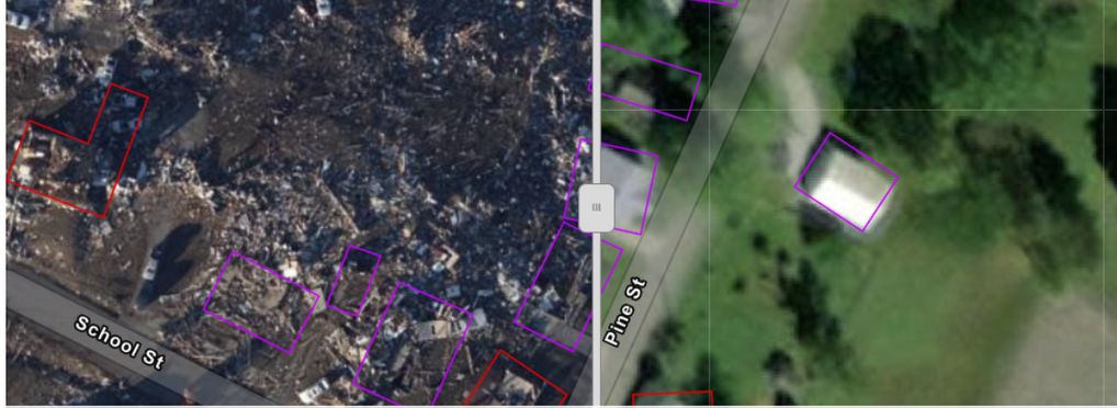
The Geospatial Damage Assessments (GDA) model is an AI tool which was first deployed in 2022 as a response to natural disasters occurring in the United States. Hosted by the United States Federal Emergency Management Agency (FEMA) this tool uses Geospatial Information Systems (GIS)-based modeling aiming to develop the capability to fully understand the aftermath and extent of natural disasters.
The GDA leverages aerial imagery, satellite data, and machine learning techniques to evaluate the damage in areas impacted by natural disasters. This tool greatly enhances the efficiency and precision of disaster response operations. This tool was used after Hurricane Ian, where the geospatial data was used to identify and categorise structural damage over one million structures. The model aims at providing an overview of the impacts and damaged caused using data such as building characteristics, wind speeds and the path of the hurricane. For the case of Hurricane Ian, the GDA model was able to reduce the number of structures requiring human review from over one million to just 77 000. This type of tools provides initial situational awareness, expedited recovery planning and cuts assessment time of the aftermath significantly.
About the tool
You can click on the links to see the associated tools
Developing organisation(s):
Tool type(s):
Objective(s):
Purpose(s):
Target sector(s):
Country/Territory of origin:
Type of approach:
Usage rights:
Target groups:
Target users:
Stakeholder group:
Geographical scope:
Tags:
- image recognition
- data
- disaster management
- geospatial information systems
Use Cases
Would you like to submit a use case for this tool?
If you have used this tool, we would love to know more about your experience.
Add use case


 Partnership on AI